Kwjcool321 (talk | contribs) |
No edit summary |
||
| Line 2: | Line 2: | ||
{{Distinguish|Object Scanner}} |
{{Distinguish|Object Scanner}} |
||
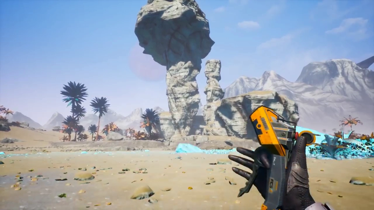
[[File:Construction Tool Scan E3.png|thumb|The Resource Scanner being used to scan the terrain.]] |
[[File:Construction Tool Scan E3.png|thumb|The Resource Scanner being used to scan the terrain.]] |
||
| − | The '''resource scanner''' is used to scan the nearby area and shows the [[Engineer]] locations of potentially useful [[Resource Node|Resources]]. By default it can scan for [[Iron Ore]], and new resources are added after completing certain [[Milestones]]. The resource scanner is the same tool as [[Construction Tool]] but the engineer handles it with the left hand. |
+ | The '''resource scanner''' is used to scan the nearby area and shows the [[Engineer]] locations of potentially useful [[Resource Node|Resources]]. By default, it can scan for [[Iron Ore]], and new resources are added after completing certain [[Milestones]]. The resource scanner is the same tool as [[Construction Tool]] but the engineer handles it with the left hand. |
== Scanning Mechanic == |
== Scanning Mechanic == |
||
* When the scan button (default {{Key|C}}) is pressed and held down, a scanning wheel resembling a circular dial will pop up. |
* When the scan button (default {{Key|C}}) is pressed and held down, a scanning wheel resembling a circular dial will pop up. |
||
* Move the mouse around the dial to choose the desired resource, then release the key to start scanning. |
* Move the mouse around the dial to choose the desired resource, then release the key to start scanning. |
||
| − | * A cyan spherical surface will then propagate outward from the scanner. Three nearest patches of the chosen ore type will be scanned; their directions would be indicated on the [[Compass]]. Three pings sounds will then be played relative to their distances. If the resource patch is at the direction within the game window, lines will be drawn from sky and point down to the exact [[Resource Node|Node]] locations, regardless if the nodes are directly within the line of sight. Circles will be drawn, indicate the number, the locations and the exact elevations of the nodes. |
+ | * A cyan spherical surface will then propagate outward from the scanner. Three nearest patches of the chosen ore type will be scanned; their directions would be indicated on the [[Compass]]. Three pings sounds will then be played relative to their distances. If the resource patch is at the direction within the game window, lines will be drawn from the sky and point down to the exact [[Resource Node|Node]] locations, regardless if the nodes are directly within the line of sight. Circles will be drawn, indicate the number, the locations and the exact elevations of the nodes. |
* The resource will be scanned regardless if the Engineer has built a [[Miner]] on top of it. After 3 nearest patches are scanned, the scanning process stops. |
* The resource will be scanned regardless if the Engineer has built a [[Miner]] on top of it. After 3 nearest patches are scanned, the scanning process stops. |
||
| − | * On the [[Compass]], the icon of the resource ore will be indicated with white background, with nearest resource patch having the largest icon size. |
+ | * On the [[Compass]], the icon of the resource ore will be indicated with white background, with the nearest resource patch having the largest icon size. |
| − | * A single quick tap will trigger the re-scanning of the |
+ | * A single quick tap will trigger the re-scanning of the previously chosen resource type. |
* After 25 seconds, the resource indications would disappear from the compass. Re-scan if needed. |
* After 25 seconds, the resource indications would disappear from the compass. Re-scan if needed. |
||
| Line 48: | Line 48: | ||
Currently in Early Access, the [[Geyser]] uses the same icon as [[Crude Oil]] in the compass when scanned. It is believed that it is the placeholder graphic. |
Currently in Early Access, the [[Geyser]] uses the same icon as [[Crude Oil]] in the compass when scanned. It is believed that it is the placeholder graphic. |
||
| − | Also, the scanning pulse can be used as some sort of radar to guide the engineer in f.e. dark and foggy areas like caves (evtl. with poison gas vents, which worsen the view on top). The pulse will expand |
+ | Also, the scanning pulse can be used as some sort of radar to guide the engineer in f.e. dark and foggy areas like caves (evtl. with poison gas vents, which worsen the view on top). The pulse will expand circularly, indicating all surfaces of walls and other properties it is passing by. |
==Gallery== |
==Gallery== |
||
Revision as of 12:03, 2 March 2020
| This article is a stub. You can help Satisfactory Wiki by expanding it. |
The Resource Scanner being used to scan the terrain.
The resource scanner is used to scan the nearby area and shows the Engineer locations of potentially useful Resources. By default, it can scan for Iron Ore, and new resources are added after completing certain Milestones. The resource scanner is the same tool as Construction Tool but the engineer handles it with the left hand.
Scanning Mechanic
- When the scan button (default C) is pressed and held down, a scanning wheel resembling a circular dial will pop up.
- Move the mouse around the dial to choose the desired resource, then release the key to start scanning.
- A cyan spherical surface will then propagate outward from the scanner. Three nearest patches of the chosen ore type will be scanned; their directions would be indicated on the Compass. Three pings sounds will then be played relative to their distances. If the resource patch is at the direction within the game window, lines will be drawn from the sky and point down to the exact Node locations, regardless if the nodes are directly within the line of sight. Circles will be drawn, indicate the number, the locations and the exact elevations of the nodes.
- The resource will be scanned regardless if the Engineer has built a Miner on top of it. After 3 nearest patches are scanned, the scanning process stops.
- On the Compass, the icon of the resource ore will be indicated with white background, with the nearest resource patch having the largest icon size.
- A single quick tap will trigger the re-scanning of the previously chosen resource type.
- After 25 seconds, the resource indications would disappear from the compass. Re-scan if needed.
Scanner Updates
| Tier | Milestone | Resource |
|---|---|---|
| - | Unlocked at start | Iron Ore |
| 0 | Hub Upgrade 1 | Copper Ore |
| 0 | Hub Upgrade 2 | Limestone |
| 3 | Coal Power | Coal |
| 3 | Caterium Technology * | Caterium Ore |
| 4 | Explorer * | Raw Quartz |
| 4 | Explosives * | Sulfur |
| 5 | Oil Processing | Crude Oil |
| 6 | Advanced Caterium Electronics * | Geyser |
| 7 | Nuclear Power | Caterium Ore**, Uranium |
| 7 | Bayer Process | Raw Quartz**, Bauxite |
| 8 | Particle Enrichment | S.A.M. Ore |
- *Need M.A.M. Research for Milestone.
- **If that particular resources is not discovered in the earlier tier. For example, Caterium Ore will be unlocked automatically at Tier 7, but if the player picked up the ore earlier, then its scanner will be unlocked earlier at Tier 3.
Trivia
Currently in Early Access, the Geyser uses the same icon as Crude Oil in the compass when scanned. It is believed that it is the placeholder graphic.
Also, the scanning pulse can be used as some sort of radar to guide the engineer in f.e. dark and foggy areas like caves (evtl. with poison gas vents, which worsen the view on top). The pulse will expand circularly, indicating all surfaces of walls and other properties it is passing by.
Gallery
| |||||||||||||||||||||||||||||